Tuesday, September 12, 2006

Sabal Palm Audubon Sanctuary (Brownsville)

(A sabal palm at Sabal Palm Audubon Sanctuary at Brownsville)

In southeast Brownsville, you'll find the Sabal Palm Audubon Sanctuary, which was acquired by the National Audubon Society in 1971. The Rio Grande delta was once blanketed by thousands of acres of palms. The largest surviving remnant of this forest can be found here. Not far from the sanctuary's parking lot, you'll pass what looks like a haunted house. I found out later that it's the Rabb Plantation House.

The sanctuary has four short hiking trails. For me, the Resaca Loop Trail (1.1 miles, 1.8 km), which includes a wetlands bridge, was the most interesting. In certain places, it really felt like a jungle. According to the Texas Handbook by Joe Cummings, in 1930 this area was chosen for the filming of a movie because of its resemblance to West Africa.

Links:

Saturday, August 12, 2006

Brazos Island State Park

(Brazos Island State Park, looking towards Rio Grande)


(Portuguese Man O' War washed ashore at Brazos Island State Park)

Brazos Island State Park, also called Boca Chica State Park, is located about 6 miles (9.7 km) from Port Isabel as the crow flies. However, to arrive there by car you must go the long way by taking Highway 48 into Brownsville and then taking Highway 4 (Boca Chica Boulevard) back the same direction. Both ways are roughly 23 miles (37 km).

Highway 48 runs along the Brownsville Ship Channel, a 17-mile (27.4 km) waterway that runs from Brazos Santiago Pass to the Port of Brownsville, which opened in 1936. Along Highway 4, about 12 miles (19.3 km) from Brownsville, is a historical marker commemorating the Battle of Palmito Ranch, a Civil War battle that occurred 34 days after Lee surrendered at Appomattox. Apparently, news traveled slow in those days, which was unfortunate for the casualties of this pointless battle. The historical marker is about all there is to see, so it's a brief stop.

Further along, we passed a border patrol checkpoint on the opposite side of the road. On our way back we got to answer the usual "are you U.S. citizens" kinds of questions.

You know you've reached the park when Highway 4 turns into sand (keep driving and you go into the ocean). This area is sparsely developed and the beach has no facilities. I don't even remember seeing any portable toilets. If you are trying to get away from it all, this is the place to go.

If you take a right and go south you'll eventually reach the mouth of the Rio Grande. Located on both sides of the river once stood two towns that thrived during the Civil War, Clarksville on the U.S. side and Bagdad in Mexico. With a Union blockade in effect, the Confederacy managed to export their cotton by transporting it to Bagdad. The Union could not interfere with the trade once it was on the Mexican side of the border.

The shipping of cotton from Clarksville to Bagdad ended in 1863 when Union forces captured the area. Afterwards, cotton still made its way to Bagdad, but its transport originated further west along the river. Clarksville declined after this, and at the end of the Civil War, Bagdad followed. In 1867, a hurricane destroyed both towns.

Waking along the shore of Boca Chica beach we spotted several of these small blue, balloon-like objects. I had no idea what they were. Later, I found out they were the bodies of Portuguese man-of-war that had washed ashore. I was thankful I didn't touch one because even dead they can give a painful sting.

South Padre Island Beaches

South Padre Island Beach(South Padre Island Beach)


South Padre Island, Isla Blanca Park(South Padre Island, Isla Blanca Park)

Being a Houston resident, I'm somewhat starved for nice beaches with clean water. On the trip to South Padre Island I was hoping to see both. I did, sort of. The public beaches that line Gulf Boulevard weren't the best. The sand was dirty, and I was hoping the water would be cleaner. Later, a clerk at a beach supply store told me her favorite beach area was at Isla Blanca Park. The next day we visited this southernmost point of South Padre Island. After paying the 4 dollar entrance fee, we drove around until we found what looked like a good spot. The quality of the sand was much nicer. The water was still just okay, but it was better than what I was used to. The visit would have been more enjoyable if not for the strong winds and mini sandstorm that hit the beach. We evacuated quickly to the showers (another Isla Blanca plus) to wash off the sand.

After returning from vacation, I saw an interesting article in the July 2006 edition of National Geographic. The article, "Land on the Edge," talks about the state of America's coastlines. It says that Padre Island is a "catcher's mitt for tons of trash each year." There are pictures of hazardous materials crews at Padre Island National Seashore cleaning up the oil industry's garbage that regularly washes ashore.

How much this affects South Padre Island the article didn't say.

Tuesday, August 01, 2006

Laguna Madre Nature Trail (South Padre Island)

Laguna Madre Nature Trail

Laguna Madre Nature Trail


Central Power and Light
Next to the South Padre Island Convention Centre and Whaling Wall is the Laguna Madre Nature Trail, a 1500 ft (457 m) boardwalk that spans over a wetlands area. The boardwalk was nice, but I couldn't understand why it was built adjacent to a Central Power and Light Company station. I found it disconcerting walking over a wetlands area and hearing the hum and crackle of electrical lines. Later, I learned that the power company built the boardwalk as part of a mitigation project due to destruction caused from the placement of underground lines.

The July 2006 edition of Texas Parks & Wildlife magazine ranked the Laguna Madre Nature Trail boardwalk number 3 in a top 10 list of Texas boardwalks. On this same trip, I walked the boardwalk at Sabal Palm Audubon Center (Resaca Loop Trail) at Brownsville; this boardwalk got honorable mention. I thought the Sabal Palm's boardwalk was more memorable; I actually said "wow" when the jungle opened up before me. The power plant boardwalk elicited a "yikes."

That being said, I would visit the boardwalk again. It offers a great place to view birds when they are around, and, supposedly, it offers an ideal spot to view sunsets.

Links:

Wednesday, July 26, 2006

Whaling Wall #53 (South Padre Island)

Whaling Wall
Gracing the walls of the South Padre Island Convention Centre is a huge mural done by the artist Wyland. To increase public awareness for all sea life (not just whales), he made it his goal to complete 100 such Whaling Walls throughout the world by the year 2011; currently, he's on number 84. His first mural was completed in 1981 at Laguna Beach, California. After much persistence, the city of South Padre Island convinced him to paint a Whaling Wall in their town, which he did in March 1994. He has murals all over the United States, as well as in Mexico, Canada, France, Japan, Australia, and New Zealand.

Links:

Sunday, July 23, 2006

City of South Padre Island

Padre Island used to be a continuous 113-mile (182 km) stretch of barrier island. In 1962, with the completion of the Mansfield Channel, a North and a South Padre Island were formed.

South Padre Island is approximately 34 miles (55 km) long, bounded by Brazos Santiago Pass to the south and the Mansfield Channel to the north. On the other side of the Mansfield Channel is North Padre Island and the beginning of Padre Island National Seashore. Padre Island National Seashore runs for about 66 miles (106 km), and the remaining 13-or-less miles (21 km) of Padre Island takes you towards Corpus Christi.

South Padre Island has a city of the same name located at its southernmost tip. The city of South Padre Island is hugely popular with the spring break crowd. I didn't know quite what to expect when I visited, but I was expecting it to be bigger. The town proper is only about 5 miles (8 km) long and about 1/2 mile (.8 km) at the widest point.

The layout is nice and simple. Padre Boulevard (Park Road 100) is the main drag through the center of town. Turn towards the Gulf of Mexico and you hit Gulf Boulevard. Turn towards Laguna Madre and you hit Laguna Boulevard. Both Laguna Boulevard and Gulf Boulevard have numerous access points to their respective bodies of water.

On the south side of the city is the popular Isla Blanca Park and the relatively new Schlitterbahn Beach Waterpark, which opened in 2001. On the north side of town is Andy Bowie Park, the convention centre with its Whaling Wall, and a scenic boardwalk. While traveling the length of the town, you'll pass restaurants, clubs, beach supply stores, hotels, and various other accommodations.

We visited during the off-season (mid-May), so traffic was minimal and getting around was easy. What it's like when the crowds arrive, I can only imagine.

Links:

Thursday, July 13, 2006

Queen Isabel Inn (Port Isabel)

Queen Isabel Inn

Queen Isabel Inn
One place we stayed during our visit to south Texas was the Queen Isabel Inn, a Texas historic landmark. Our room was comfortable with plenty of amenities. It had a DVD player, and you could borrow DVDs from the Inn's collection. The bathroom was stocked with almost every item you could have possibly forgotten from home. The full kitchen also had everything you needed, except for food, which could be found at the huge HEB in town. Eating breakfast at the room saved us time and money. The most surprising thing to me was that this 100-year-old Inn had wireless internet access; this was definitely a plus.

The atmosphere of the place was laid back, and the owner John Haywood was very friendly. Originally from Brownsville, he purchased the Inn in 1978. As you would guess, he's very knowledgeable of the area. He seemed to enjoy talking to guests, and seemed very concerned whether we were having a good time (we were).

When the Queen Isabel Inn opened in 1906 it was called the Point Isabel Tarpon and Fishing Club. It was located adjacent to a Rio Grande Railroad depot. The Rio Grande was a 22.5 mile (36.2 km) track that opened in 1872 and connected Point Isabel to Brownsville. (Note: The depot is no longer there, but the city does have plans on building a Rio Grande Railroad Park, which would include a pavilion modeled after the original depot.)

The Inn was the beginning of the hotel and tourism industry that would later define the area. Recently, the Queen Isabel Inn received the Texas Treasure Business Award from the Texas Historical Commission for its active community involvement over the last 100 years.

Links:
  • One of the most famous visitors to the Inn was President-elect Warren G. Harding. In November 1920, before his inauguration, Harding visited Republican party leader Rene Creager at his home in Brownsville. Later, Harding went fishing around Point Isabel. See photo of Harding fishing at Brazos Santiago.

Tuesday, July 04, 2006

Another Lighthouse View (Port Isabel)

Port Isabel Lighthouse
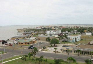
We're standing atop the Port Isabel Lighthouse looking out in a southeastern direction. South Padre Island is on the horizon and the body of water in view is the Laguna Madre. The white building in the center of the photo (closest to the water), is the Queen Isabel Inn, which was built in 1906.

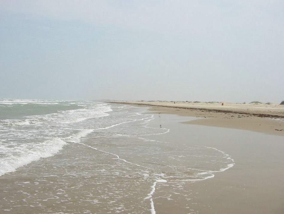
If you wanted to take a ship and head out to the Gulf of Mexico, you would go in this general direction. At the far southern tip of South Padre Island is an opening called Brazos Santiago Pass, which would take you to the Gulf. While making your way through the pass, you would have South Padre Island to your left, and on your right would be Brazos Island. On Brazos Island was located Brazos Santiago.

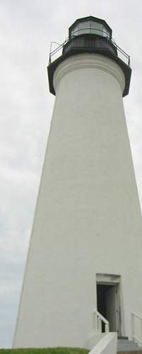
In 1850, the U.S. Congress appropriated 15,000 dollars to go towards a lighthouse and beacon for the port at Brazos Santiago. Local authorities agreed that the lighthouse should be placed at Port Isabel and the beacon should be placed at the southern tip of South Padre Island.

The beacon, as it turned out, was a light mounted on a wooden structure, and the wooden structure rested on wheels. It went into service in August 1852, and in less than a year's time there were already complaints, one of which was that it burned too much oil. Around 1855, a new wooden structure was built and a new light was installed.

During the Civil War, the beacon's light was turned off, as was the case for all Texas lighthouses at this time. After the war, the light returned, but it shone from Brazos Island instead of South Padre Island. A temporary wooden structure three stories tall was placed there, and it was put into operation on August 24, 1864. This temporary structure was used for almost a decade until a hurricane blew it away in September of 1874. This storm also took the life of the lighthouse keeper's wife.

Another temporary light was set up to replace the former temporary light.

The Lighthouse Board thought it was time for a permanent lighthouse and suggested an iron lighthouse of the screw-pile variety that would be placed in a shallow section of water at the southern end of South Padre Island. Congress gave the go-ahead, and the new Brazos Santiago Lighthouse went into service on March 1, 1879. This lighthouse stayed in operation for sixty-one years. It was destroyed by fire on March 7, 1940. Shortly afterwards, a new beacon was placed on a nearby Coast Guard station.

Books:

Baker, T. Lindsay, Lighthouses of Texas, College Station: Texas A&M University Press, 2001

Links:
  • Check out the great photo of Brazos Santiago Pass that was taken using kite aerial photograpy! For more photos of the South Texas coast, check out the main site here.

Friday, June 23, 2006

Lighthouse at Port Isabel

Lighthouse at Port Isabel
On the day we visited the Port Isabel Lighthouse, there were several bus loads of school kids taking a field trip to the lighthouse and the surrounding museums. We managed to slip in between groups.

From the outside, the lighthouse did not appear that tall to me, but that impression quickly changed after climbing the steps and looking out from the top. It's plenty tall, and the gusty day guaranteed an even firmer grip on the railing that circled the top platform.

Next to the lighthouse is the lighthouse Keeper's Cottage, which now houses the Chamber of Commerce. The facility has an interesting exhibit on the history of the lighthouse, and this is where you buy lighthouse tickets. We purchased a combination ticket where you can visit the lighthouse and two other museums in town, all within walking distance of one another. The combination ticket is 7 dollars a person; at 3 dollars a site, you save 2 dollars.

Lighthouse History

Before the lighthouse, there was Fort Polk. Tensions were heating up with Mexico after the U.S. annexed the Republic of Texas, which Mexico viewed as a slap in the face. Despite the Republic of Texas winning independence from Mexico in 1836, Mexico never really conceded their loss. To prepare for potential trouble, President Polk sent General Zachary Taylor into south Texas. General Taylor arrived at Port Isabel, which was then known as El Fronton de Santa Isabel, in the Spring of 1846.

The fort was built where the lighthouse now stands and was used as a supply depot and hospital during the war that eventually ensued. Additionally, the town was renamed Point Isabel. The war ended in 1848, and, two years later, the army handed the fort over to the U.S. Treasury Department for customs service use.

In 1850, with urging from Texas delegates, Congress appropriated 15,000 dollars for two navigational aids to serve the harbor at Brazos Santiago. One of these navigational aids was to be a lighthouse, the other a beacon. At first, South Padre Island was considered for the lighthouse location, but local shipping experts argued that the Fort Polk location offered a more stable foundation and was protected more from the onslaught of hurricanes. Also, the government already owned the land at Fort Polk. In the end, this location won out, and South Padre Island got the beacon.

Unlike the cast iron lighthouses serving Galveston and Matagorda at this time, the Port Isabel Lighthouse was constructed with brick. The lighthouse was completed in 1853 and first lit the night sky on March 20, 1853. The light remained lit until the beginning of the Civil War in 1861. Confederates removed the light so it would be useless if Union hands got a hold of it. Two years later, they really tried making it useless by blowing up the tower with gunpowder. The lighthouse survived the explosion and was later repaired. It shone again, after the war, on February 22, 1866.

Things went well until 1882 when the Lighthouse Board realized they had no title papers for the lighthouse. Four years later, the board received a letter from James B. Wells Jr. who claimed ownership; that following year, he sued the lighthouse keeper for trespassing on his property. The board wanted to purchase the property, but Wells' offer of 6,000 dollars was considered exorbitant, so, in 1888, the lighthouse went out of service because of the land dispute.

In 1894, after public pressure to restore the lighthouse, the Lighthouse Board settled out of court with Wells, purchasing the lighthouse and land for 5,000 dollars. On July 15, 1895, the light once again shone from Point Isabel. This lasted for 10 years. With the completion of railways into south Texas, the lighthouse was deemed unnecessary for commerce. It went dark for good on August 1, 1905.

In January of 1928, the lighthouse was sold. It went to the highest bidder, who happened to be a J.S. Ford. He purchased it for 2,760 dollars and turned around and sold it two months later to the Port Isabel Town Company for 5,000 dollars. The town company wanted the landmark to help promote the town, which they renamed Port Isabel, for tourism and industry. The town company later went bankrupt, succumbing to the depression.

In 1947, the Texas Legislature said it was ok for the Texas State Parks Board to acquire the lighthouse, and they put up 25,000 dollars for its repair and maintenance. The state didn't own the property, but this was not an issue. The owners Mr. and Mrs. Lon C. Hill, Jr. donated the lighthouse and surrounding land as a gift in 1950. (I would bet that Lon C. Hill, Jr. is the son of the founder of Harlingen; see a previous post on Harlingen.)

On April 26, 1952, the lighthouse was dedicated as a state park. The Port Isabel Lighthouse is the only lighthouse on the Texas Gulf Coast open to the public.

Books:
  • Baker, T. Lindsay, Lighthouses of Texas, College Station: Texas A&M University Press, 2001

  • Parent, Lawrence, Official Guide to Texas State Parks, Austin: University of Texas Press, 2000

Return Home


Thursday, June 22, 2006

Lighthouse View (Port Isabel)

Lighthouse at Port Isabel
Leaving Harlingen, we continued to Port Isabel (pop. 4,900), less than an hour's drive away. This picture was taken atop the Port Isabel Lighthouse.

On the horizon is South Padre Island with its numerous hotels. South Padre Island is one of many barrier islands that run parallel to the Texas coast protecting it from high tides, storms, and erosion.

The body of water between Port Isabel and South Padre Island is Laguna Madre. On the other side of South Padre Island is the Gulf of Mexico.

In the foreground is the restaurant Pirate's Landing; the food and service were excellent on the particular afternoon we were there. Between Pirate's Landing and the pier is a huge yellow fly fishing rod. It's a Guinness World Record holder, projecting into the air at 71 feet, 4.5 inches long (21.75 m).

On the right is the Queen Isabella Causeway. Completed in 1974, it connects Port Isabel to South Padre Island. At 2.37 miles (3.81 km), it's the longest bridge in Texas. This causeway replaced the original 1954 causeway, which was located further south (to the right of the photo). Before the causeways, people had to go by ferry.

On September 15, 2001, ferry travel returned after four loaded barges hit the causeway taking out two 80-foot (24.4 m) sections; a third 80-foot section collapsed later. Cars plunged into the 50-foot (15.24 m) deep Laguna Madre; eight people died in the disaster. The causeway was reopened on November 21, 2001.

Links:

Thursday, June 15, 2006

Railroads and Dutch Ancestors: The Naming Of Harlingen

Harlingen was founded in the early 1900s by Leonidas Carrington Hill (Lon C. Hill). He was a lawyer from Beeville, Texas who was on his way to Brownsville to work a case when he recognized the area's potential. His initial land purchase was the Cameron County school lands in 1902. Later, in 1904, he would purchase additional land from Henrietta Chamberlain King (of King Ranch fame).

In 1904, the town got an official name, mainly out of necessity, for a new railroad was coming through, and, well, you need a name for your railroad station. Now, you would think that Hill would name the town after himself, something like Hillsville. Instead, the name Harlingen was chosen, and was suggested by Col. Uriah Lott, president of the railroad company building the rails and a major figure in railroad construction in south Texas.

(That same year, Hill did have the town of Lonsboro named after him, but it was later renamed to its current name Mercedes, located about 15 miles (24.14 km) west of Harlingen.)

He suggested Harlingen because his maternal grandmother's name was Eliza Van Harlingen, and she just so happened to be born in Harlingen, New Jersey, which just so happened to be named after a village in the Netherlands, which just so happened to be the home of her (and his) ancestors. The fact that planned irrigation canals for the area would give the town a certain Dutch flavor sealed the deal. Harlingen would go on to become officially incorporated in 1910.

Links:
  • Handbook of Texas Online, Uriah Lott (accessed June 17, 2006)
  • Handbook of Texas Online, Lon C. Hill (accessed June 17, 2006)

Wednesday, June 14, 2006

Forever Living Aloe Plantation (Harlingen)

The south Texas valley region is billed as the aloe vera capital of the nation, and in Harlingen you can find the Forever Living Aloe Plantation. We decided to check it out, but, unfortunately, our expectations were set a little too high.

You enter a main room with side offices and wait for someone from one of those side offices to walk out and notice you. It wasn't a long wait, but you begin to wonder if you entered through the correct door; I didn't see any signs that offered guidance.

After being noticed, we were directed to a viewing room to watch a 15 minute video, which was interesting and informative. One thing I got out of the video is that aloe vera is difficult to harvest, requiring a lot of workers who have to gently handle each plant.

Afterwards, back in the main room, we checked out samples of different aloe vera products. I was interested in purchasing some of these products, but there were none to be seen, just samples. This time, no one came from a side office to assist us. Looking at samples can only hold the interest for so long, so we decided to leave. On our way out someone emerged from one of the offices and said that we could have a free aloe vera plant. We had enough aloe vera plants at home, so we declined.

I imagine that our experience would have been different if we hadn't come during an off time. This was a Friday morning in the middle of May. I was disappointed that I came away empty handed after being prepared to shell out some cash. Perhaps we'll try another time when they're more prepared to see visitors.

Thursday, June 08, 2006

Iwo Jima Monument (Harlingen)

Iwo Jima Monument at Harlingen
You don't have to go to Arlington, Virginia to see the Iwo Jima Monument. At the Marine Military Academy in Harlingen they have the original, full-sized working model that was used to cast the famous bronze replica. The monument was donated by the sculptor Felix W. de Weldon in 1981 and officially dedicated in April 1982.

Tuesday, June 06, 2006

Murals (Harlingen)

Bill Haley mural at Harlingen
Recently, my wife and I went on vacation to south Texas. One city that really impressed me was Harlingen (pop. near 60,000). You know you are getting close to Harlingen when you start seeing palm trees crop up everywhere. They're all over town and give the place a nice tropical feel, a reminder that you are not too far from the beaches of South Padre Island.

The downtown Jackson Street District is a great downtown with 30+ murals at various locations. The mural above is of Bill “Rock Around the Clock” Haley, a former resident of Harlingen. The Harlingen Chamber of Commerce, also located downtown, offers an informative guide to all the murals.